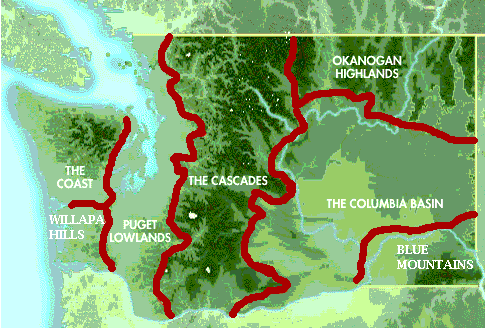
The rain shadow has affected the east and west of the cascades .The reason is that the clouds soak up the water from the lakes and or the Pacific ocean and goes to the east.Toward the East is the Olympic mountains.The rain shadow doesn't really affect that Mountain but when the clouds go passed the next body of water, it goes straight to the cascades. the west sight of the cascades is the greenest and its more wet plus don't forget its a lot more green! But the clouds lose the water when the clouds rise and when the go over the top of the mountain , its light and there is very little water left.For intents its like a sponge that you just rang out and your trying to ring it out again after you walk a few feet with it. when it gets to the east side of the mountain there is no water to keep the east side green. So that's when the Columbia basin comes in. the Columbia basin is very dry and has very little vegetation.I think that the rain shadow affect is more about the rising and falling through the warm and cold air. the warm air can make it sink and the colder air can rise the cloud.


 The three most plausible theories on the migration routes of Native Americans into Washington State is the Land Bridge; Which is if the sea dropped several hundred feet then today and exposed land,the Ice bridge; Which is the water froze, and the Continental Shelf; which Asia and North America were connected. I feel that the land bridge is most believable because the land bridge has evidence such as fire pits and shelter built at the bottom of the Bering Strait. In the Book called Washington: A State of Contrasts by Dale A. Lambert tells all about the Native Americas, Coastal and Plateau . The picture to the high left is of Plateau Indians and to the right is Coastal Indians. Under the plateau Indians is the land bridge theory.